Beyoglu is the best-connected district in Istanbul, and that is one of the quiet reasons so many travelers base themselves here. The M2 metro serves both ends of the district, the ferries dock at its feet, the funiculars climb through its middle, and the airport shuttles terminate at Taksim Square — the district’s own front door. The only real challenge is the arrival, because Istanbul has two major airports on opposite sides of the city, and the right route depends on which one you land at. This guide untangles both, then maps the district’s transport so you can move through it with confidence.
The Two Airports: Know Before You Land
Istanbul’s two airports are effectively in different worlds:
Istanbul Airport (IST) is the giant, on the European side, roughly 40 kilometers northwest of the city. Most international flights land here. It is an hour from Beyoglu by road and the best-served airport for the district.
Sabiha Gökçen (SAW) is on the Asian side, used by many budget and domestic airlines. It is farther from the district in spirit but well connected by rail and shuttle.
Check your ticket carefully — the two airports are over an hour apart from each other, and arriving at the wrong one at 5 a.m. is the classic Istanbul travel disaster.
From Istanbul Airport (IST) to Beyoglu
Three routes, in order of practicality:
The Havaist shuttle to Taksim (easiest). The airport bus company runs a direct, frequent service from IST to Taksim Square — the top of Istiklal, the heart of Beyoglu. Around an hour to an hour and a half depending on traffic, roughly 136 lira. This is the sensible default with luggage.
Metro to metro (cheapest). Take the M11 from the airport into the city’s rail network, connect to the M2 line, and ride to Taksim or Şişhane — the district’s two metro stops. Slower, with transfers, but a fraction of the cost.
Taxi. The fixed-fare taxis run around 600–900 lira and take 40–60 minutes. Use the official rank, confirm the fare, and avoid the drivers who approach you inside the terminal.
From Sabiha Gökçen (SAW) to Beyoglu
The rail route (recommended). Take the M4 metro from the airport to Ayrılık Çeşmesi, transfer to the Marmaray line across the Bosphorus, then connect to the M2 metro toward Taksim or Şişhane. About an hour and a half, cheap, and reliable.
The shuttle (simplest). Airport shuttles run directly from SAW to Taksim — the no-transfers option most travelers with bags choose. From Taksim, everything in Beyoglu is downhill or a funicular away.
Taxi. Possible but the longest and priciest option; the rail and the shuttle both beat it.
The District’s Own Network
Once you’re here, Beyoglu’s transport is the easiest in Istanbul:
- The M2 metro serves Taksim (north) and Şişhane (south) — the district’s two ends — and connects to the city’s whole rail network.
- The Tünel funicular runs between Karaköy and the bottom of Istiklal — the 1875 underground railway, history you ride.
- The Kabataş funicular climbs from the T1 tram’s Kabataş stop up to Taksim Square.
- The ferries dock at Karaköy and Kabataş — the islands, the Bosphorus, the Asian side, all at the district’s feet.
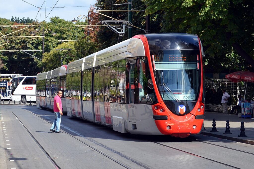
- The T1 tram runs along the shore from the old city to Kabataş, linking Beyoglu to Sultanahmet in twenty minutes.
- The Galata Bridge connects the district to the old city on foot — the most scenic crossing in Istanbul.
One Istanbulkart covers all of it: the metro, the trams, the funiculars, and the ferries, at roughly half the single-ticket price. Contactless bank cards also work on most readers.

Getting Around: The Practical Choices
- Walking is the district’s real transport. The avenue is pedestrian, the hills are manageable, and the neighborhoods are compact. Most visitors walk everywhere and use the funiculars for the climbs.
- The funiculars beat the taxis. The Tünel and the Kabataş funicular are part of the experience and always quicker than the traffic.
- The ferries are the scenic route. The crossing to Kadıköy or up the Bosphorus is a tourist attraction in its own right — and cheaper than a bus.
- Taxis for the late nights and the luggage. Use the licensed ranks or the app-based fares (Uber’s local mode and the official taxi app), and agree the price or the meter before you set off.
- The night network. When the metro sleeps, the night buses and the night dolmuşes carry the city, and the main ferries run until around midnight.
The Travel Times That Matter
The distances of the district are the practical arithmetic of the stay, and the numbers are the reassuring ones. To the old city: the T1 tram from Kabataş to Sultanahmet runs about twenty minutes, and the Galata Bridge walk is the scenic quarter-hour — the monuments of the historic peninsula reachable without a single transfer. To the Asian side: the ferries from Karaköy and Kabataş reach Kadıköy and Üsküdar in fifteen to twenty minutes — the Bosphorus crossing as the daily commute. To the airports: Istanbul Airport (IST) runs an hour to an hour and a half by shuttle or rail, and Sabiha Gökçen (SAW) about an hour via the metro-and-ferry route. Across the district itself: the metro spans Taksim to Şişhane in three minutes, the Tünel two, and the walk of the avenue is the twenty-minute baseline.
The practical version: Beyoglu is the rare base where nothing is far. The day-trip arithmetic — the old city by tram, the islands by ferry, the airports by shuttle — all starts from the district’s two transport anchors, Taksim and Karaköy, and the Istanbulkart that covers every leg. The visitor who memorizes those four journeys has the whole city in reach, and the district’s transport stops feeling like logistics and starts feeling like the view.

The Night and the Early Morning
The transport of Beyoglu runs past the usual hours, and the visitor who knows the night network moves freely. The metro and the tram run until around midnight, and the night buses — the metrobus and the night lines of the city — carry on through the small hours, the avenue’s nightlife emptying into them. The ferries run late on the main lines — the last Karaköy crossings to the Asian side often after midnight — and the night dolmuşes (the shared minibuses) ply the main routes until dawn, the city’s own answer to the late return. The taxis and the ride apps fill the gaps at the standard fares, and the official ranks at Taksim and Karaköy are the reliable ones.
For the early departures, the airports’ first flights are served by the night shuttles and the pre-dawn buses — the Havaist and the municipal services run through the early hours — and the district’s two anchors mean the traveler is never far from a connection. The practical rule: the Istanbulkart covers the night buses as it covers the day, the apps work around the clock, and the district that never sleeps is the district that is never stranded.
Practical Transport Tips
- Buy the Istanbulkart at your first station. It works across the whole system and it is the single best travel purchase in Istanbul.
- Avoid rush hours with luggage. The M2 at 8:30 a.m. and 6 p.m. is a scrum; travel off-peak with bags or take a taxi.
- Confirm your hotel’s exact location. “Beyoglu” covers Taksim, Pera, Galata, and Karaköy — a hill and a ten-minute walk apart. Know which one you’re aiming for.
- The last metro and ferries run until around midnight. After that, the night buses and the taxis take over.
- The airport shuttles from Taksim are the return route. Allow more time on the way out; the traffic is the variable.

The Takeaway
Beyoglu’s transport is the model of how a great city district should work: two metro stops, two funiculars, the ferries at the door, and the whole system on one card. From either airport the route resolves to the same two words — get to Taksim — and the district does the rest. Arrive with an Istanbulkart and a confirmed address, and you will spend your days walking, riding, and ferrying through the best-connected corner of Istanbul.
Frequently asked questions
Which airport is easier for Beyoglu?
Istanbul Airport (IST) — its shuttle runs directly to Taksim Square. Sabiha Gökçen works via the Marmaray and the M2, or the direct shuttle to Taksim.
Is there a metro stop in Beyoglu?
Yes, two: Taksim and Şişhane, both on the M2. The avenue runs between them.
How do you get from Sultanahmet to Beyoglu?
T1 tram to Karaköy, then the Tünel up the hill — about twenty minutes. Or the tram to Kabataş and the funicular to Taksim.
Can you walk across to the old city?
Yes — across the Galata Bridge from Karaköy, about thirty minutes to Sultanahmet. The bridge crossing is the scenic route.
Do you need a taxi in Beyoglu?
Rarely — the district is walkable, and the funiculars, the metro, and the ferries cover the rest. Taxis are for luggage, late nights, and tired legs.

All Over Information
The All Over Information editorial team researches and writes practical English-language guides to Turkey. Facts are checked against official and local sources before publication, prices are published as dated ranges rather than quotes, and guides are revised when things change. We accept no sponsored posts, paid placements or paid links.
More guides like this

Hidden Gems of Beyoglu Most Tourists Miss
Istiklal Avenue is Beyoglu's billboard, and it is where most visitors spend their time — walking the same kilometer of shops and…

Shopping Guide: What to Buy in Beyoglu
Beyoglu is the shop window of modern Istanbul — the district where the old crafts and the new design scene stand side…

A Solo Traveler’s Guide to Beyoglu
Beyoglu is the solo traveler's natural habitat in Istanbul.
Beyoglu in Winter: What to Expect
Beyoglu in winter is Istanbul's cosiest district — and its most contradictory.

The Best Day Trips from Beyoglu
Beyoglu sits at the northern end of Istanbul's transport web, which makes it one of the best bases in the city for…

Best Time of Year to Visit Beyoglu
Beyoglu is a four-season district, and each season sells a different version of it.